CDN NEWS |
  US NEWS


Author: Carter Morrison

As methane detection strategies evolve, operators are turning to an expanding range of technologies to support both regulatory compliance and voluntary emissions reduction goals. A common debate in this space is whether aerial surveys are “finding more” emissions than traditional ground-based Leak Detection and Repair (LDAR) methods.
The answer is more nuanced than it may first appear.
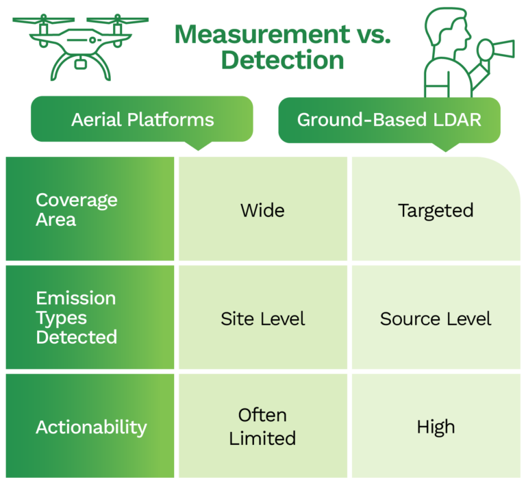
Understanding the Difference: Measurement vs. Detection
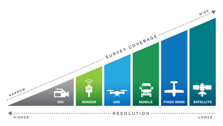
Aerial platforms, whether aircraft, drone, or satellite-based, are effective for identifying site-level methane emissions and generating aggregate measurements. However, these measurements are not the same as source-level measurements.
Ground-based LDAR programs, particularly those using Optical Gas Imaging (OGI) and SEMTECH HI-FLOW 2 samplers, are built for precision detection and measurement—identifying specific, repairable components such as valves, flanges, or malfunctioning controllers. These programs are essential for compliance with regulations that target fugitive emissions, and they remain the primary tool for actionable leak repairs.
The perception that aerial platforms “find more” often stems from fundamental differences in purpose, scope, and constraints:
- Regulatory Programs (e.g., AER Directive 060, U.S. EPA OOOOb) prioritize compliance, cost-effectiveness, and identification of leaks that are repairable within defined timelines.
- Voluntary Frameworks (e.g., OGMP 2.0, GTI Veritas) aim to quantify total site-level emissions—including designed or non-repairable sources like venting or combustion slip—primarily for emissions inventories, ESG reporting, and capital planning.
- Budget and Logistics considerations also shape outcomes. Certain regulatory programs (such as Alberta’s alt-FEMP) allow for limited follow-up to aerial surveys based on emission thresholds (e.g., 10–30%), which often uncover designed emissions with limited mitigation potential.
Key Insight: Not All Methane Is Equal
Distinguishing between fugitive leaks and vented or designed emissions is critical. These categories are treated differently under both regulatory and voluntary programs, and conflating the two can lead to misguided investments or compliance gaps.
- Fugitive leaks are typically repairable and regulated.
- Vented or designed emissions may be permitted and require different strategies to mitigate.
Detection strategies must be fit-for-purpose. If your goal is regulatory compliance, OGI and ground LDAR are indispensable. If your goal is full-site quantification or ESG reporting, aerial or satellite measurement can play a complementary role, but not in isolation.
Leveraging Existing Data for Smarter Decisions
Operators already have access to robust datasets (Inventory database collection, LDAR programs etc.) that contain volumetric data by source type (e.g., tanks, pneumatics, flares), and when integrated with detection campaigns, can:
- Identify high-volume vented sources
- Prioritize CAPEX investments in vapor recovery units (VRUs), combustors, or flare improvements
- Validate return on investment prior to launching new measurement campaigns
These datasets are powerful tools for strategic planning when paired with direct measurement and ground verification.
Integrating Tools for Maximum Impact
There is no one-size-fits-all approach. The most effective emissions detection programs integrate multiple tools and data sources, allowing operators to optimize both accuracy and actionability:
- Aerial platforms help identify high-emitting sites and guide resource deployment
- Ground LDAR teams verify, classify, and repair emissions at the component level
This layered strategy aligns with the goals of OGMP 2.0, GTI Veritas, and other frameworks demanding transparency and granularity.
Addressing Common Misconceptions
Let’s tackle a few recurring questions:
“Don’t aerial surveys prove that ground teams are missing leaks?”
Not necessarily. Aerial tools report total emissions, including venting, flare inefficiencies, or combustion slip, not just repairable leaks. Ground teams are focused on what can be repaired in compliance with regulations.
“Isn’t ground LDAR too slow or expensive for remote areas?”
Not when deployed strategically. Ground teams often follow established inspection routes and use historical leak data to guide efforts. Their value lies in source verification and precision—something aerial tools cannot deliver alone.
“Why not just use aerial and skip boots-on-the-ground?”
Top-down tools show where emissions are occurring, but not what is causing them. Ground verification is still required to:
- Differentiate leaks from designed vents
- Comply with repair mandates
- Justify and validate project investments
“Isn’t more data always better?”
Only if it’s actionable. Without context, more data can lead to false positives, misprioritized efforts, and unnecessary costs. Integrated datasets—rather than siloed results—unlock real operational value.
Conclusion: Purpose-Driven Detection for Real Results
As regulations tighten and stakeholders demand more credible emissions reporting, operators need more than just advanced tools, they need a framework for deploying them strategically.
By combining aerial screening, ground verification, and public datasets, methane detection becomes not only more comprehensive but also more meaningful. The result is a program that delivers:
- Regulatory compliance
- ESG performance
- Capital project alignment
- Stakeholder confidence
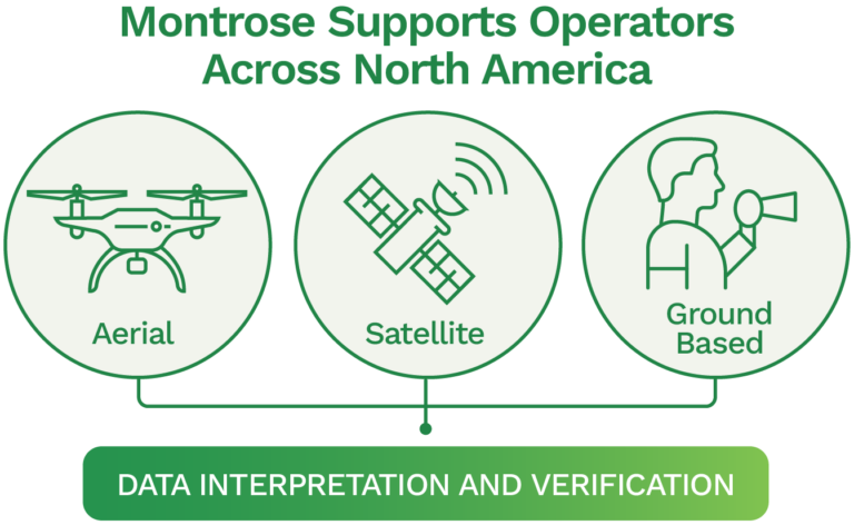
Montrose supports operators across North America offering integrated solutions across aerial, satellite, and ground-based platforms, with data interpretation and verification to match. Whether your goal is emissions reduction, ESG reporting, or operational optimization, our integrated approach ensures results you can act on with confidence. Connect with our team to explore how Montrose can support your regulatory, ESG, and operational goals with integrated solutions that deliver results.
Share This: