CDN NEWS |
  US NEWS


Simplifying processes has a long history because we naturally tend to break down complex tasks, and we have gradually learned to automate repetitive and tedious tasks. This tendency is the result of our burning desire to manage time since there is no possibility to replicate it.
Ironically, the first thing that comes to mind at the time of exposure to a brand new solution— capable of managing time efficiently—is the associated cost of deploying that solution. As such, in many cases, jobs are still getting done with the traditional methods that are not always the best alternative because they waste both financial and non-financial resources such as time.
Finding an instant and reliable remedy may seem hard to attain in a situation like that. However, our cutting-edge software, Matidor.com, is the ultimate solution that you are looking for. Inspired by the real-time notion, Matidor can save you between three to five man-hours per project on a daily basis. By cutting down data retrieval time from hours to minutes, you and your team can spend your time on more important tasks and stay organized.
Allow geospatial data to play their role in real-time
Transferring field data to the office is a never-ending process in managing location-based projects, that is mainly done with antiquated methods. Despite the fact that these data are the fundamental parts of managing location-based projects, project managers have to spend considerable effort and time retrieving them from different platforms, including spreadsheets, docs, email, etc.
As a result, we have come up with new product features and releases every other week to cater to the demands of the industry, in the following paragraphs we will discuss how each feature will cut down unnecessary time spent when managing projects.
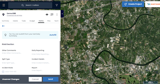
Autofill Forms is designed to eliminate repetitive data entry when you are working with forms; in particular, if you have to fill the same information into a form over and over. Once you fill out and save a form on your device, the ability to autofill activates automatically. It appears the next time you want to fill out the same form. You can simply click the autofill button and then make any necessary adjustments to the data and save.
New Templates is designed to provide ultimate freedom and customization when you are building templates for your company. The new structure allows you to create templates independently in three main categories of Project Templates, Budget Templates and Form Templates.
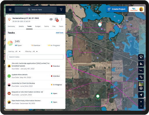
Matidor empowers your team to finish their daily activities sooner with the special features designed to cut the admin work and stay productive. Build up project templates ahead of time for your company, and then just pick the templates to enter the data. Fill your QA/QC forms quickly by using the outfield and track the project process step by step. Define the level of access and invite as many members as you want to your company to watch the real-time progress together.
The results of the above features will empower you and your team to cut down wasted time on repetitive tasks and invest the saved time on more important tasks such as data analysis. Our platform has dozens of other powerful features to enhance your fieldwork.
Important Announcement – Matidor Made Available on ArcGIS Marketplace for Existing Esri Users!

We will leave this article on a high note as we are thrilled to announce our official listing on the ArcGIS marketplace!
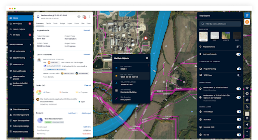
Made available on the ArcGIS marketplace, the platform can now offer existing users the ability to enhance their Geographic Information System (or GIS) experience through add-ons such as displaying key project details like budgets, tasks, and files. This one-stop solution gives companies total visibility over their entire operation portfolio on a map, which can be zoomed in at any time for a specific project’s site layout, tasks, budgets, docs, chats and historical activities.
“A lot of users have been asking us to connect Matidor with their own ArcGIS instances, so that they can pull in the relevant GIS layers in real-time,” said Vincent Lam, the co-founder and CEO at Matidor.com. “And now I am glad to announce that their wish has come true – users can now overlay their favorite satellite imageries, infrastructure network, survey plans and other layers while working tracking their project operations.”
Existing ArcGIS Users can now connect to their ArcGIS accounts using their Esri credentials, which will enable them to access the ArcGIS layers and assets within seconds. ArcGIS users can then use the GIS data to enhance their project management within Matidor by associating locations with their chats and activities. The ArcGIS-enabled Matidor platform is accessible easily through any web browser with, the best part, an unlimited user model.
If you are interested to learn more please check out the link below to see our listing on the marketplace!
https://www.esri.com/en-us/arcgis-marketplace/listing/products/4e42161e1dc64caaaee72202bd25e149
Once again thanks for reading this month’s coverage on Matidor, we have more exciting news to come and If you would like to explore more features like these, don’t hesitate to book a free demo with us.
Share This: